


River Processes
Describe and explain processes of erosion, transport and deposition by rivers.
River Processes
Describe and explain processes of erosion, transport and deposition by rivers.


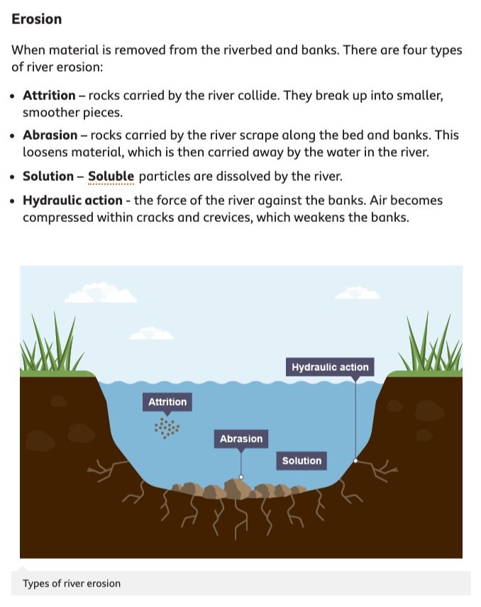
A river removes material from the sides (banks) and bottom (bed) of the river channel. This is called erosion.
The boulders, pebbles, sand, silt and mud are carried downstream. This is called transportation. The material being transported is called the load.
When the river loses energy it deposits material on the river bed. The largest material (boulders) are deposited first.
FACTORS AFFECTING EROSION IN RIVERS
TASK 1: Note the 6 factors affecting erosion in rivers.
There are many factors affecting erosion in rivers. These include:
load – the heavier and sharper the load the greater the potential for erosion
velocity and discharge – the greater the velocity and discharge the greater the potential for erosion
gradient – increased gradient increases the rate of erosion
geology – soft, unconsolidated rocks, such as sand and gravel, are easily eroded
pH – rates of solution are increased when the water is more acidic
human impact – deforestation, dams and bridges interfere with the natural flow of a river and frequently end up increasing the rate of erosion.
PROCESSES OF EROSION AND TRANSPORT IN RIVERS
TASK 2: Draw two labelled diagrams explaining the processes of erosion and transportation.
RIVER EROSION PROCESSES
RIVER TRANSPORT PROCESSES

REVIEW
River Landforms
Describe and explain the landforms associated with river processes
River Landforms
Describe and explain the landforms associated with river processes
River Landforms
A landform is a physical feature in the land, formed by a physical process. River landforms are caused by the processes of erosion, transportation and deposition.
The main landforms in a river can be divided into two types; those found in the upper valley (highland area) and those found in the lower valley (lowland area).
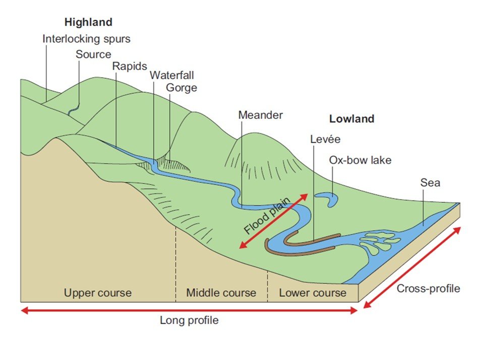

UPPER VALLEY RIVER LANDFORMS
V-SHAPED VALLEY
V-shaped valleys are found near the source of a river, where the river has more energy and is able to erode and transport more material. V-shaped valleys are formed as rivers transport material along their beds, especially by traction and saltation. As this occurs, the material cuts downwards (vertical erosion) relatively quickly, deepening the bed of the river. After periods of heavy rain, soil on the valley sides slowly moves downhill under gravity by rainsplash and soil creep. The valley forms a V-shape as it is deepened faster than it is widened. Interlocking spurs are also formed as the river meanders in the valley, leaving hills, which have not been subject to erosion, jutting out on each side of the river channel

WATERFALLS & GORGES
Waterfalls occur where there is a band of hard rock lying on top of softer rock. The river erodes the softer rock more quickly than the harder rock. This forms a ‘step’ in the river, where the water falls vertically. At the base of the waterfall, the falling water erodes the softer rock and undercuts the hard rock creating an overhang.
Eventually, the overhang will collapse under its own weight. The rocks which break from the overhang forms large blocks at the base of the waterfall. These are slowly broken up by erosion. The loose rocks swirl round at the base of the waterfall and erode a deep plunge pool.
Over many years a gorge will form in front of a waterfall. This is because each time the rock overhand collapses, the waterfall retreats further up the valley. Over many years a steep-sided valley, called a gorge will be created.

LOWER VALLEY RIVER LANDFORMS
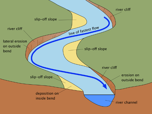
MEANDER
A meander is a bend in a river. The river’s flow is fastest on the outside bend of the meander. The outside bend is eroded and undercut to form a river cliff. On the inside bend, the river flows slowly and deposits material. The material builds up to form an area of shallow land, called a slip-off slope.
OX-BOW LAKES
During a flood, the narrow neck of land between a meander can be eroded. The river will take the shortest route possible and form a new channel. The old meander becomes cut-off as material is deposited by the river. A lake in the shape of a horse-shoe (known as an ox-bow lake) will be formed. Over time the lake will become marshy and will eventually dry up completely.

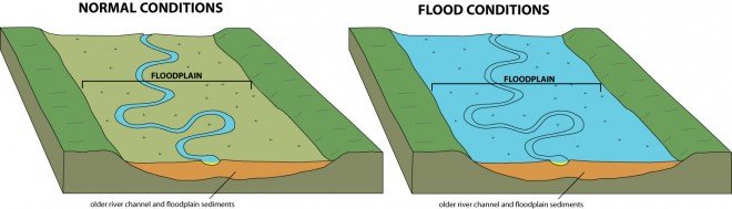
FLOOD PLAIN
A flood plain is the flat valley floor on either side of a river. Flood plains are formed by erosion and deposition. The river erodes sideways as it meanders downstream. This sideways erosion wears away interlocking spurs in lowland areas and carves out a wide valley. The valley is flooded each year when the river bursts its banks. During the flood, the river deposits layers of stone and mud. The deposited material (alluvium) builds up in layers to form a flat valley floor. Flood plains are excellent places for farming because the soil is very fertile.
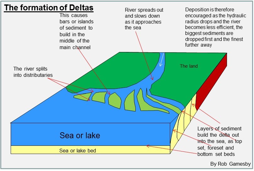
DELTA
When a river reaches the sea, it deposits its entire load except the dissolved load. The heaviest material is deposited first. If the sea is shallow, the deposited material can build up to form a delta. A delta is a low-lying area at a river’s mouth. Often the main river channel splits into many smaller channels. The smaller rivers are called distributaries, and the process is known as braiding
REVIEW